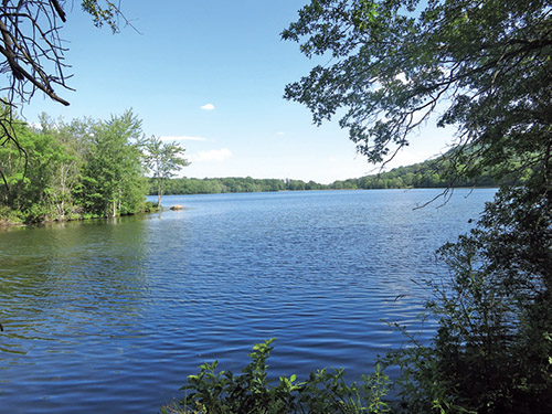
This short, level hike loops around a lake in the nearby borough of Franklin Lakes. Formerly known as the Haledon Reservoir, the lake once served as the water supply for the adjacent communities of Haledon, North Haledon and Prospect Park. The 75-acre lake and the surrounding land was acquired by the borough of Franklin Lakes in 2006 and is now known as the Franklin Lakes Nature Preserve.
Although the hike is quite easy, it offers broad views across the lake, as well as of the nearby High Mountain. Towards the middle of the hike, the trail crosses the northern end of the lake on a dike with pontoon bridges. You’ll also pass some unusual rocks along the way. The hike is about two miles long, and it should probably take about an hour to make the loop around the lake. Dogs are allowed on leash. A free trail map is available online at www.nynjtc.org/map/franklin-lakes-nature-preserve-trail-map.
To get there, take N.J. Route 4 to N.J. Route 208, and continue on Route 208 for 7.7 miles to the Ewing Avenue exit in Franklin Lakes. Turn left at the end of the ramp (if coming from the west, turn right) and continue for about two miles until Ewing Avenue ends at High Mountain Road. Turn left onto High Mountain Road and continue past a lake and a smaller pond on the left. In 0.5 miles, at the end of the smaller pond, you will see a small brown sign for the Franklin Lakes Nature Preserve on the left. Turn left into a driveway, passing old reservoir buildings on the right, drive across the dam of the Lower Pond, then turn left again at a sign for parking and continue to a parking area just below the dam of the Upper Lake. GPS address: 1196 High Mountain Road, North Haledon, NJ 07508.
From the parking area, climb up the road leading to the dam, passing to the left of the locked gate. When you reach the top of the dam, you’ll notice (on the fence on the left) a triple white blaze that marks the start of the Preserve Shoreline Loop Trail. You’ll be following this white-blazed trail for most of the way around the lake.
Turn left and cross the dam, with views of the lake to the right and of the Lower Pond to the left. At the end of the dam, turn right and follow a narrow dirt path between a chain-link fence (with High Mountain Road beyond) on the left and the lake on the right. Several short side trails on the right lead to viewpoints over the lake, and benches have been provided for those who wish to rest while admiring the views. Soon, you’ll reach an opening in the fence where the Red Trail to High Mountain Park Preserve begins on the left. The white-blazed trail now crosses an open grassy expanse and enters a wooded area.
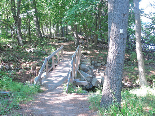
After crossing a wooden footbridge over a culvert, the trail reaches the intersection of High Mountain Road and Ewing Avenue. Here, it bears right and begins to parallel Ewing Avenue. The trail crosses an inlet of the lake on another wooden footbridge and continues beneath tall evergreen trees.
Upon reaching the intersection with Waterview Drive, go through an opening in the fence on the left and use the road bridge to cross the outlet of a wetland to the northwest. At the end of the chain-link fence, turn right and reenter the preserve (just beyond a large sign for the Franklin Lakes Nature Preserve).
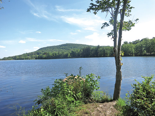
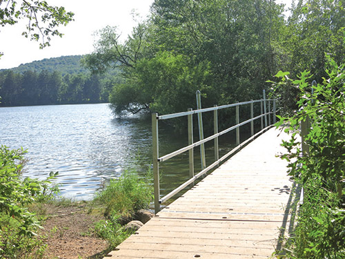
Just ahead, a signpost marks the start of the blue-blazed Island Bridges Trail. Turn right and follow this trail along a dike that juts into the lake, forming a lagoon on the left. Short paths lead out to the water on both sides of the trail, and there are fine views of High Mountain to the right (southwest). Along the way, the trail crosses two floating pontoon bridges over gaps in the dike.
Just past the second bridge, you’ll notice an open area on the shoreline across the lagoon to the left. This feature, known as Basalt Beach, is a large expanse of basalt rock (characteristic of the Watchung range). In another 500 feet, as the trail bears left, an expanse of basalt rock may be seen just to the right of the trail.
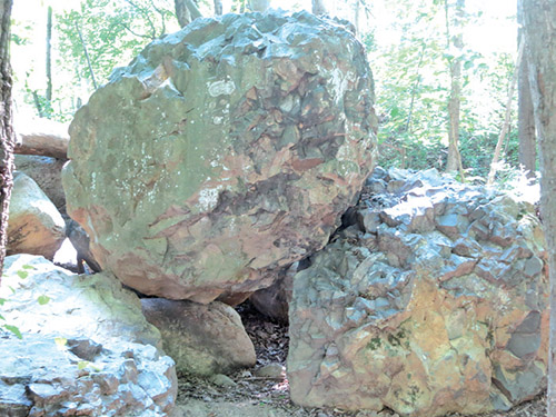
Soon, you’ll reach the end of the Island Bridges Trail at a junction with the Preserve Shoreline Loop Trail, marked by several jagged basalt boulders on the right. Turn right and follow the white-blazed Shoreline Loop Trail along a wide dirt-and-gravel woods road. After a while, you’ll pass homes on the left. Just beyond, you’ll notice a sign on the right for an Accessible Trail. The wide path on the right is a “lollipop”-loop trail that leads to a viewpoint over the lake. You can take this loop if you want to lengthen your hike a little.
Just ahead on the woods road, as you come to a pine grove, you’ll notice a continuation of the Accessible Trail on the right. You can either continue ahead on the road (the official route of the Preserve Shoreline Loop Trail) or follow the Accessible Trail, which winds through the pine forest and crosses a wetland on a pontoon bridge. Either way, you’ll reach the kiosk adjacent to the parking area where the hike began, completing the loop.
This hiking article is provided by Daniel Chazin of the New York-New Jersey Trail Conference. The Trail Conference is a volunteer organization that builds and maintains over 2,000 miles of hiking trails and publishes a library of hiking maps and books. The Trail Conference’s office is at 600 Ramapo Valley Road (Route 202), Mahwah; 201-512-9348; www.nynjtc.org. Daniel Chazin can be reached at [email protected].