
This three-mile-long hike in nearby Oakland, of moderate difficulty, is one of my favorites. Not only does it run along a scenic lake and climb to several panoramic viewpoints, but it also passes the interesting stone ruins of Foxcroft—a mansion built over 100 years ago. There are several rather steep climbs, but most of the hike follows well-graded trails and woods roads. Allow about 2 1/2 hours for the hike (dogs are permitted on leash). A free trail map (without contours) is available online at www.nynjtc.org/map/ramapo-mountain-state-forest-map.
To reach the trailhead, head west on Route 4 to Route 208, and continue on I-287 South. Take Exit 57 (Skyline Drive) and proceed north on Skyline Drive for 1.2 miles to the upper parking area for Ramapo Mountain State Forest (on the left, opposite milepost 1.4). This parking area can fill up early on weekends, so you might want to get an early start, or else do this hike on a weekday.
At the northwest end of the parking area, you will see a yellow blaze of the Hoeferlin Memorial Trail, as well as a triple red/white blaze, which marks the terminus of the Skyline Connector Trail. You will be returning to the parking area on the Skyline Connector Trail, but the Hoeferlin Trail will be your route for the first part of the hike.
Head into the woods and immediately turn left, following the yellow blazes, then bear right onto a footpath parallel to a gravel road. After passing a small pond on the right, follow the yellow blazes as they briefly turn right onto the road (this portion of the road is paved), then turn left onto another woods road. After passing an interesting rock outcrop on the right, you’ll come to a Y-intersection, where the yellow-blazed trail bears right and begins to descend.
Soon, the gravel road briefly reappears on the right, but bear left to stay on the yellow-blazed trail, which follows a rocky woods road over undulating terrain. The road eventually narrows to a footpath and crosses an intermittent stream. After descending on a winding route and once again briefly approaching the gravel road, the Hoeferlin Trail heads down to a woods road—the route of the blue-blazed MacEvoy Trail. Turn right, now following both yellow and blue blazes.
Soon, the trail bears left and descends a short pitch to the dam of Ramapo Lake (just to the left). Here, the yellow-blazed Hoeferlin Memorial Trail turns left, crossing the dam, but you should continue ahead onto North Shore Drive, following the blue blazes of the MacEvoy Trail. The MacEvoy Trail follows a gravel road along the northeast shore of the lake, passing a private home on the right and then crossing a small stream on a stone-arch bridge, with an attractive cascade to the right.
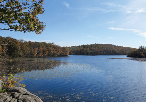
A short distance beyond, you’ll come to a rock ledge on the left that overlooks the lake. This is a good place to take a break. Once known as Rotten Pond, and later as Lake LeGrande, Ramapo Lake is the centerpiece of Ramapo Mountain State Forest. It was formerly surrounded by private property, but most of the land around the lake was acquired by the state in the 1970s.
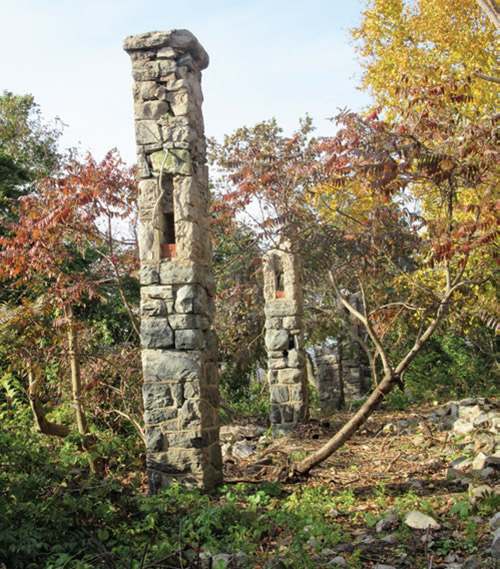
Just beyond, the trail reaches the northern tip of Ramapo Lake. Here, a triple-white blaze marks the start of the Castle Point Trail. Bear right at the fork in the road, now following both white and blue blazes, and pass between two concrete pillars. A short distance ahead, the blue-blazed MacEvoy Trail leaves to the left, but you should continue ahead on the road, now following only the white blazes of the Castle Point Trail. Just beyond, as the road curves sharply to the right, turn left, leaving the road, and follow the white-blazed trail as it climbs steadily and rather steeply.
As you approach the top of the climb, bear left onto a rock ledge that offers a spectacular view. Directly below you is Ramapo Lake, with the Wanaque Reservoir to the right (west). On a clear day, you can see the New York City skyline on the horizon to the left. You’ll want to pause here to rest from the steep climb and enjoy the view.
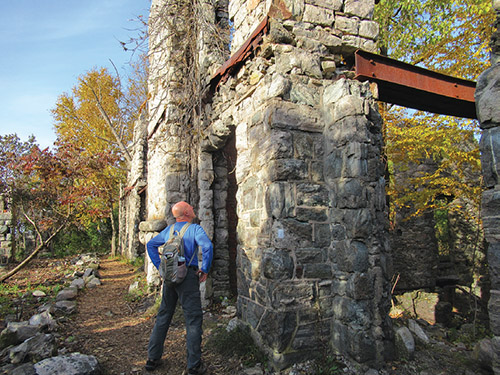
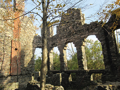
When you’re ready to continue, follow the white trail uphill. After climbing over a stone wall on a step-stile, you’ll reach the ruins of a mansion. Known as Foxcroft, it was built around 1910 by William Porter, a stockbroker. His widow occupied it until her death in 1940, and it fell into ruin in the late 1950s. Use caution if you wish to explore the remains of this once-elegant stone structure.
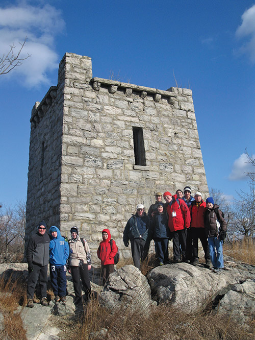
The trail continues to the north, passing the remains of a concrete swimming pool. Just beyond, the trail bears left and soon reaches an unobstructed west-facing viewpoint over the Wanaque Reservoir and the Wyanokie Mountains. Continue on the white trail, which climbs to a stone tower. Contrary to what one might think at first glance, this was not a lookout tower; rather, it held a cistern that supplied water to the mansion (note the rusted pipes adjacent to the tower). Just beyond, there is another view from an open rock ledge to the left of the trail over the Wanaque Reservoir to the west. The trail now begins to descend.
Watch carefully as the Castle Point Trail briefly turns left onto a woods road, then immediately turns right before reaching the route of a gas pipeline. It turns right again onto a woods road, turns left onto a footpath before reaching a wide gravel road, then turns right and follows the gas pipeline for 350 feet. After turning right and leaving the pipeline, the trail crosses a stream and climbs, first gradually, then rather steeply through mountain laurel, to a rock ledge with a broad view. From the ledge, you may be able to see the stone tower you passed about half a mile back.
A short distance beyond, the Castle Point Trail reaches a paved road, with Skyline Drive just to the left. Here, the Castle Point Trail ends, and you turn right to continue along the Cannonball Trail (white-“C”-on-red blazes). The trail follows the road for 200 feet, then turns left onto a footpath through the woods. Soon, you’ll reach a junction where the red/white-blazed Skyline Connector Trail begins on the left. Turn left and follow this red/white trail along a footpath roughly parallel to Skyline Drive until you reach the parking area where the hike began.
This hiking article is provided by Daniel Chazin of the New York-New Jersey Trail Conference. The Trail Conference is a volunteer organization that builds and maintains over 2,000 miles of hiking trails and publishes a library of hiking maps and books, including a two-map set for North Jersey Trails ($10.95). The Trail Conference’s office is at 600 Ramapo Valley Road (Route 202), Mahwah; 201-512-9348; www.nynjtc.org. Daniel Chazin can be reached at [email protected].
By Daniel D. Chazin
�