
If you’re looking for a short hike of easy-to-moderate difficulty, this hike is perfect for you. It’s only 1.5 miles long, and you probably can finish the hike in one hour. But you might want to spend a little more time admiring the beautiful scenery, as the hike goes by two scenic lakes. Boy Scout camps were formerly situated on these lakes, and along the way you’ll have the chance to observe some historical relics from their former use. Although the hike begins and ends in Ramapo Mountain State Forest, both lakes are located on property owned by Bergen County. Dogs are permitted on a leash.
To reach the trailhead, head west on Route 4 to Route 208, and continue on I-287 South. Take Exit 57 (Skyline Drive) and proceed north on Skyline Drive for 1.2 miles to the upper parking area for Ramapo Mountain State Forest (on the left, opposite milepost 1.4). This parking area can fill up early on weekends, so you might want to get an early start, or else do this hike on a weekday.
From the parking area, cross Skyline Drive. You will see a triple orange blaze on a telephone pole, marking the start of the Schuber Trail, as well as a triple white blaze, which marks the end of the Todd Trail. The Todd Trail will be your return route, but for now, follow the orange blazes of the Schuber Trail, which turn right onto the paved road that leads into the former Camp Tamarack, then immediately turn left at a kiosk and proceed downhill on a winding footpath.
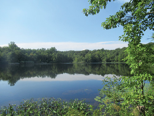
At the base of the descent, the trail passes the ruins of the former rifle range of Camp Tamarack. Just ahead, with the ruins of the camp’s former archery range visible on the left, a triple purple-on-white blaze on the right marks the start of the Tamarack Trail, which was blazed in the fall of 2016 by volunteers of the New York-New Jersey Trail Conference. Turn right onto the Tamarack Trail, which follows a level footpath and soon reaches the shore of Lake Tamarack. A rock ledge on the left affords a view over the lake, with a stone chimney visible across the lake on the left and remnants of the former waterfront docks of Camp Tamarack on the right (Camp Tamarack closed in 1995). This lake has been described by a leading volunteer of the Trail Conference as the most beautiful trailside lake in Bergen County.
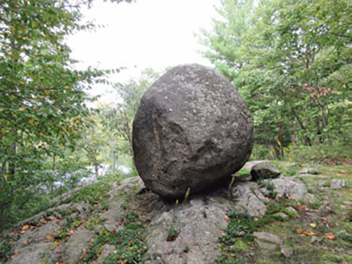
The trail continues along the lakeshore, soon passing the concrete-and-stone foundations of the former camp waterfront buildings. Here, on the left, another rock ledge offers views over the lake (note the plaque for the “Jack Brady Memorial Pier”). After passing a balanced boulder, you’ll come to a third viewpoint over the lake. The trail now moves away from the lake, joining a woods road. (To the left, the road leads to the stone dam of the lake, with an attractive waterfall when the water is high.) The trail follows the road for 150 feet, then bears left, leaving the road, and continues on a footpath.
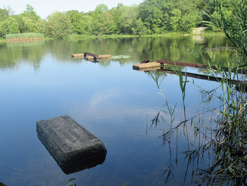
A short distance beyond, the Tamarack Trail ends at a junction with the Yellow Trail (blazed with yellow diamonds) near the shore of Todd Lake. Turn right onto the Yellow Trail, which soon goes by a stone wall on a rock ledge at water level, with a view over the lake. Todd Lake was the site of the waterfront of Camp Todd, which closed in 1985.
After taking a short break here, proceed ahead along the Yellow Trail, which continues to parallel the lake. Near the lake’s south end, the Yellow Trail turns right and soon ends at a woods road, the route of the white-blazed Todd Trail.
Turn right, now following the white blazes. As another woods road joins from the left, the Todd Trail bears right, then turns left in 100 feet and follows a footpath into the woods. After dipping into a shallow ravine, the trail begins to climb, first rather steeply, then more gradually. It levels off, descends to cross a seasonal stream in a shallow ravine, then ascends on a winding, rocky footpath, with several switchbacks. This is the most strenuous part of the hike, but it’s not exceptionally difficult. When it reaches Skyline Drive, the trail turns right and continues for about 200 feet to the triple white blaze marking the terminus of the Todd Trail, opposite the parking area where the hike began.
By Danny Chazin
�